You are viewing an archived version of Ocean Planning in the Northeast.

Archived on January 3, 2018

Return to the current version of the site

Ocean Planning in the Northeast

Website for the Northeast Regional Planning Body Northeast RPB Projects Maritime Commerce

Maritime Commerce and Ocean Planning

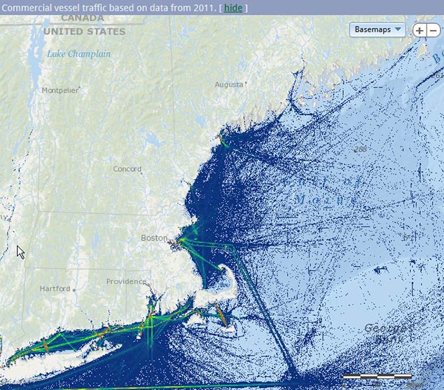
Shipping and maritime commerce have defined the historical, cultural, and economic development of New England for hundreds of years. Today, the waters of the northeastern United States include important maritime commerce routes that accommodate some 4,000 transits of commercial ships and 8,000 transits of cargo barges each year. Each year, new ocean uses add pressures to port infrastructure and shipping lanes.

Navigating the sometimes-unforgiving ocean conditions, maritime shipping companies compete with overland-based transportation companies moving goods along the Interstate 95 corridor. They must operate just above the profit margin to attract and maintain clients who demand that products reach their destinations on a tight schedule. To keep maritime shipping costs as low as possible, vessels transport goods along the shortest distance, least-cost path; even a minor change to a route could increase the cost of shipping.

Ocean planning can help ensure an efficient and competitive maritime transport industry. It can provide tools to analyze the operational and economic implications for the shipping industry of ocean use decisions and policies, and can support the better integration of regional transportation planning across road, rail, and water modes.

Links, Documents, and Reports

What’s Been Done

Initial steps in ocean planning for New England have focused on understanding the current state of maritime commerce in the region. In November and December 2012, at five working sessions with regional ocean planning staff throughout New England, industry representatives discussed key issues and changes facing the region’s maritime commerce sector, the role of regional ocean planning in addressing issues and opportunities, and the status of data characterizing maritime commerce in New England. Summaries from these working sessions (PDF) (19pp, 618K) are available. Drawing on these conversations and other existing information, a maritime commerce expert prepared a white paper summarizing the state of the maritime commerce in the region (PDF) (15pp, 783K).

Industry representatives have also reviewed maps of critical navigation and operational areas, potential hazards affecting maritime operations, and commercial vessel traffic using Automatic Identification Systems (AIS) data, NOAA nautical charts, and other data sources. Ocean planning staff have revised draft maps, incorporating industry suggestions and changes, for inclusion in the data portal.

In early 2015, ocean planning staff convened a series of meetings with ports and shipping representatives from New York through Maine to discuss updated AIS-based maps. These maps contained updated data and also explored the utility of separating types of shipping traffic (tug/tow separate from cargo, tanker, passenger vessel, etc.). Additional focal points of the discussion included future trends and emerging issues.

Contacts at national- and international-level shipping associations also provided feedback on these topics. Results of these meetings and discussions will be summarized for RPB review and discussion at its upcoming meetings.

Schedule of Meetings:

  • March 10, 2015: Massachusetts Port Authority (Massport); Boston, MA
  • March 18, 2015: Port of Portsmouth Advisory Commission Meeting; Portsmouth, NH
  • March 18, 2015: Port of New York & New Jersey Harbor Operations Commission Meeting; New York City, NY
  • April 14, 2015: Connecticut Maritime Coalition, Newington, CT
  • March and April, 2015: several additional meetings with Maine and Rhode Island ports and maritime commerce contacts

The maps, data sets, and white papers created during this process will feed into the ocean planning process being implemented by the Northeast Regional Planning Body.

Key Highlights/Takeaways

Key issues to consider in ocean planning for maritime commerce:

  • Pressure is increasing for container ports to deepen navigation channels to accommodate larger container ships because of international industry trends, the expansion of the Panama Canal, and other economic factors. At the same time, maintenance of current channel depths is an ongoing challenge and options for disposal of associated dredge material are limited.
  • Regulations to achieve environmental objectives (such as prevention of right whale ship strikes or reduction of air pollution) could affect the ability of shipping companies to operate in their preferred or established way. These regulations may also disproportionately affect different types of marine commerce.
  • Energy development and future development of ”coastal highways”—moving people and cargo by sea rather than land or air—may require port expansion and could increase commercial traffic in certain areas.
  • The cruise ship industry is becoming increasingly important in New England, requiring long-term planning for scheduling assurance.
  • Climate change is expected to affect facilities and infrastructure through rising sea levels, increased storminess, and coastal flooding.

Key data gaps and limitations identified by industry stakeholders and experts:

  • Industry participants identified additional data to include on maps, such as pilot boarding areas, traditionally used anchorage grounds, hazardous areas, and unofficial routes preferred during inclement weather.
  • Industry participants identified limitations of AIS data (their reliability and completeness), but also gave guidance on further analysis of AIS to understand patterns associated with different types of marine commerce.
  • Data on the economic implications of shifts in commercial vessel traffic and cargo flows, as well as models of regional transportation across the marine/land boundary, could help inform ocean planning for the region.

Next Steps

  • As a result of recent discussions with the industry, ocean planning staff are working to develop new data to characterize the maritime use of ocean waters in the Northeast. This includes maps of traffic patterns by vessel type and cargo using AIS, pilot boarding areas, safety and security zones, and traditionally used anchorages.
  • Over the next several months, relevant agencies and industry representatives will be asked to review these and other interim information products. Agencies and industry representatives will also be asked to consider industry-related issues as they relate to regional ocean planning goals and objectives.

Example Map

Map of commercial vessel traffic on the Northeast Ocean Data website. All maps are developed through a scientific process that incorporates input from industry, scientists, and managers.

Northeast RPB News

November 15 Northeast RPB Data Workshop Remote Access Webinar Available

November 14, 2017— Webinar available for remote access to November 15 RPB Data Workshop.

More...

Ocean Planning Timeline

  • November 2012 Inaugural Northeast RPB Meeting: Develop common understanding about the RPB; provide context and lay foundation of regional ocean planning; engage stakeholders and the public, discuss initial focus.
    April 2013 Northeast RPB Meeting: Northeast RPB Meeting: Identify draft goals for regional ocean planning and mechanisms for receiving public input about those draft goals; provide opportunities for public input about topics under consideration.
    May/June 2013 Public Comment Meetings: Ten public meetings throughout New England to discuss draft regional ocean planning goals.
  • January Northeast RPB Meeting: approve goals and objectives; move forward on related tasks.
    May/June Public Engagement: Natural Resources Workshops and focused engagement to discuss progress toward goals of effective Decision-Making and Healthy Ocean and Coastal Ecosystems.
    June Northeast RPB Meeting: Review progress toward all goals.
    Fall Public meetings/workshops and Northeast RPB meeting: Feedback on progress toward each goal.
  • Spring Stakeholder Forum: Review progress on the use of marine life and ocean use data, regulatory coordination, and future scenario development.
    June Northeast RPB Meeting: Review approach to developing draft plan by considering agency use of ocean plan data products; discuss draft outline for regional ocean plan.
    Fall Northeast RPB meeting and public meetings: Review revised products for each goal; discuss future work of the RPB.
  • Winter EBM Working Group: Review progress on Draft Northeast Ocean Plan, marine life and habitat data product development, including IEAs Framework.
    Spring Northeast RPB Meeting (via webinar): Release Draft Plan for public review.
    Summer Collect public comment on the Draft Plan through public meetings and other opportunities.
    Fall September public webinar to review changes to the Draft Plan and October submittal of revised Plan to the National Ocean Council.
  • Winter Northeast RPB members and federal principals of the National Ocean Council sign Plan Adoption Memo.
    Spring See Events and Meetings
    April Informational webinar to prepare for stakeholder forum.
    May Stakeholder forum and RPB public meeting.

Visit RPB News Archive...